

Fall City’s Aquifer
Understanding our Aquifer and why LOSS is unsuitable in this location
This page shares information on the groundwater and geohydrology of Fall City, our aquifer and how the proposed developments significantly impacts the quality of the groundwater.
It is not a technical report. It is a plain-language report written for the Fall City community. It draws on the developer's reports, independent analysis commissioned by Fall City Sustainable Growth, testimony from King County Hearing Examiner proceedings, and Washington State groundwater quality law.
FCSG makes no claim that this document is the final word - we are actively collecting data on groundwater conditions, LOSS operations, and how King County will handle this new precedent in a critical area. This document is intended to give the community a clear accounting of what the evidence shows and what the law requires.
Background on the developments
Taylor Development has proposed seven large on-site sewage systems for new residential subdivisions in Fall City. Each system would collect sewage from multiple homes, treat it to a basic standard, and discharge the treated effluent directly into the ground beneath the drainfield. That effluent then enters the shallow groundwater system underneath Fall City.
What’s below Fall City?
To understand the impacts of the developments on groundwater, it helps to understand what is actually underground.
Beneath Fall City sit two separate water-bearing layers. The shallow layer is an unconfined aquifer that sits below most of the town boundary including the drainfield sites. It is formed in the gravel and sand deposited over thousands of years by the Raging River alluvial fan, the broad, flat spread of material a river drops as it slows where it meets a valley floor. The gravel the shallow aquifer lays in is highly permeable: water moves through it quickly (on the lower end, 20 feet per day, at other times at 200+ feet per day). The gravel continues to roughly 60 to 65 feet below grade, where it meets a thick layer of silt and clay that separates the shallow system from the deeper aquifer below. Due to the variable deposition of different sediments and gravels over time, some areas may be more prone to contamination than others.
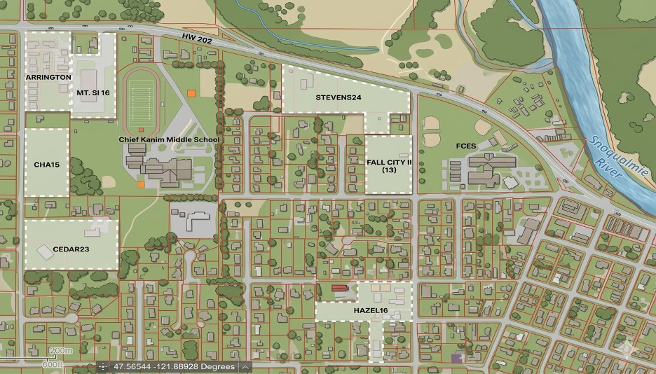
The deeper, confined aquifer is where the Fall City Water District's public supply wells are located and pumping water. There are three main wells serving the town including two wells at the FCWD on SE 43rd St (adjacent to the proposed Hazel development) and a third well located at Chief Kanim Middle School (in close proximity to most of the developments). The deep aquifer is separated from the shallow system by 70 to 80 feet of low-permeability silt and clay. Decades of water quality testing show the District's primary production wells do not contain measurable nitrate, which is consistent with hydraulic separation at those well locations. Nitrate is highly soluble and once in an aquifer, it can persist for decades creating legacy nitrate plumes under areas with high septic density like Fall City. If our water became contaminated over the EPA allowed 10 mg/L concentration, we would have an expensive treatment problem and increased water service costs. Treatment options might include captial projects costing a few million dollars and the cost per gallon of water could increase 5-10x. Currently, there are about 143 individual septic systems within 1000 feet of our primary wells and we have no alarms or infrastructure to support a major event.
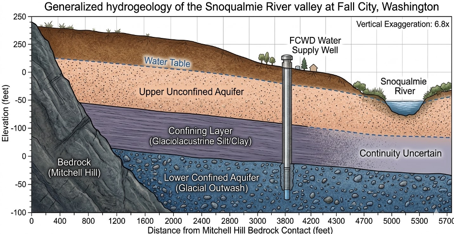
The integrity and continuity of the confining layer has been a focus for FCSG because various sources in the literature make different claims about its extent.
At this time, the best available science comes from Taylor Development's Riley Report, the Snoqualmie Tribe's groundwater monitoring at the floodplain restoration project (located where the Rainier wood recyclers facility used to be), and independent analysis by Aspect Consulting. Based on these sources, we feel more confident about the integrity of the confining layer near the primary drinking water wells. However, there is general agreement across these studies that as you move closer to the Snoqualmie River, the confining layer may be disturbed or less intact. The studies show our area is variable and not uniform. It is likely water finds unique pathways to move through the layers following a path of least resistance and gravity. Additionally, old improperly decommissioned wells can puncture confining layers and serve as direct pathways for contamination to reach the deeper aquifer. We have not yet researched the status of historic wells in the project area.
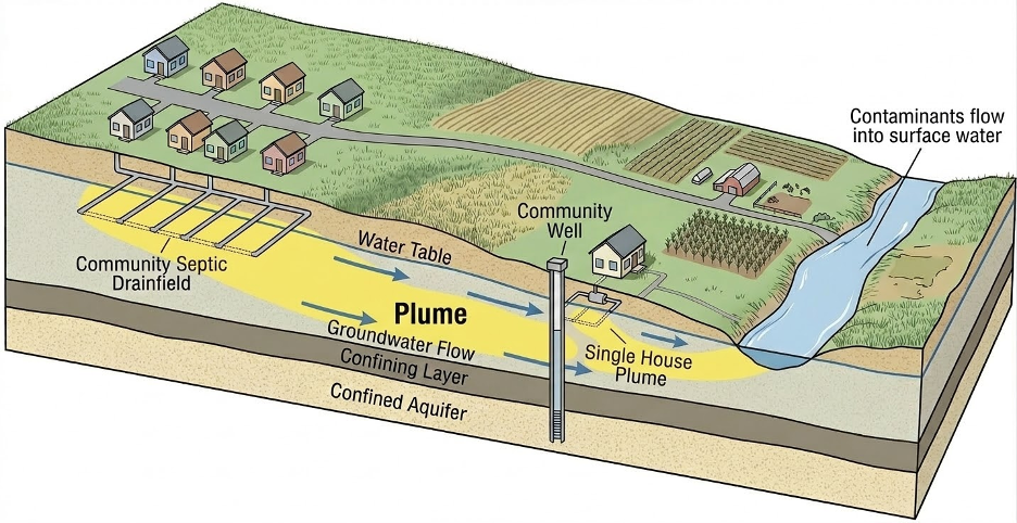
Septic wastewater and stormwater runoff enter the shallow aquifer
The shallow aquifer receives discharge from the developments’ LOSS and stormwater facilities. Our individual onsite septics also discharge into the aquifer. Technically, all septic effluent is expected to stay within the property where it is discharged and systems must be designed and maintained so that effluent does not leave the parcel, surface, or impact neighboring properties or waters. The codes say septic systems must treat and disperse wastewater within the approved drainfield area. A system is considered failing if effluent migrates onto neighboring properties or into streams or rivers. Subsurface flow does not respect property lines but is still regulated under “no contamination” standards. Due to the high hydraulic conductivity of our soil (how fast water moves underground), it is likely that cumulative discharge is hydraulically carried “downgradient” towards the Snoqualmie River. The shallow aquifer becomes a conveyor belt delivering nitrogen to the river.
This dynamic was documented in detail by Kindred Hydro + Geo LLC in a two-year hydrogeologic study commissioned by the Snoqualmie Indian Tribe. The study monitored shallow groundwater elevations and temperatures within and adjacent to the Snoqualmie River Salmon Restoration Project (former Rainier Wood Recyclers site) from October 2021 through November 2023. The Stevens 24 drainfield is located within 150 horizontal feet of the monitored zone; the Mt. Si and Fall City II drainfields are within 1000 feet, making the findings highly transferable.
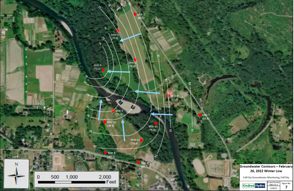
The monitoring wells showed groundwater temperature varied by season - warming in summer, cooling in winter. This seasonal temperature signal appeared in the river, proving groundwater discharge to the river is occurring. Combined with the water level data showing the aquifer and river rising and falling together during floods, this confirms the shallow aquifer and the Snoqualmie River are directly connected.
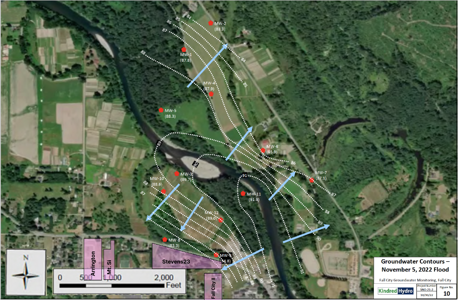
Here, you can see the general direction of the gradient during low-flow conditions. The red dots are monitoring wells and the blue arrows show the direction of flow.
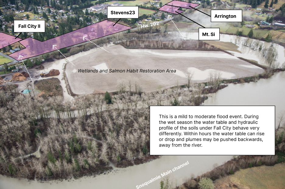
In the next image, you can see how the gradient changes during a high-flow event. Within hours and days the water table rises and the gradient reverses direction - towards town.
The Tribe’s extensive monitoring data establish the following material facts:
The shallow alluvial aquifer (groundwater) and the Snoqualmie River (surface waters) are hydraulically connected.
Groundwater flow direction and water table elevations exhibit high variability driven by rain and river flows, and are not steady-state conditions.
These findings establish that pollutants discharged to the unconfined aquifer will reach the surface waters of the river. The nature of that transport is affected by seasonal conditions and river flow dynamics: pollutant loads may accumulate gradually during low-flow periods or be mobilized rapidly during flood events. Washington law protects groundwater and surface water as interconnected resources. These findings establish that LOSS discharges to the Fall City aquifer are discharges to the Snoqualmie River.
Understanding the dynamics of the hydraulics is critical to modeling or predicting how a plume may behave. Will it get to the wetland or river in 1 week or 1 year? Will one plume run into another and join forces on their way towards the river? Does pumping from our wells change the direction of flow? Does mounding under the stormwater facilities push water back towards a drainfield? During the summer months, will a plume grow in concentration and then be swept quickly away during the first big rain event?
At this time, no agency has required the developer to answer these questions.
LOSS treats incoming wastewater (influent) from people’s homes before it discharges it as effluent to the drainfield. This process reduces nitrogen and eliminates pathogens. Stormwater is not treated directly. It is collected from roads, rooftops, and driveways and directed into infiltration facilities where it soaks directly into the ground. Because it runs off impervious surfaces, it carries nitrogen from vehicle exhaust, atmospheric deposition, and organic matter with it.
Below each discharge point, the water and its dissolved load do not simply disappear into the ground. They move downward through the gravel, reach the water table, and form a plume: a zone of elevated contaminant concentration that travels with the groundwater. Once in the unconfined aquifer, that plume begins moving away from its source, in a direction and at a speed governed by many forces such as pressure, gravity, and permeability and porosity of the soil. In summer it moves slowly. After a large rain event it moves faster. Groundwater moves faster down a steep hillside and slower on flat terrain. When the river floods it may slow, stop, or temporarily reverse. If there is a layer or ribbon of clay, the groundwater needs to move and find its way around it. Clay can create perched groundwater and fractures can create preferential pathways. Groundwater does not flow in straight lines and often bends, splits, or concentrates.
Aquifer-River Connectivity and Hydraulic Gradient Reversal
In the dry summer months, the water table drops, groundwater moves slowly and generally toward the northwest, and the gradient between the drainfield zone and the river is at its flattest. Travel time from a drainfield to the river under these conditions, based on available hydraulic data, could be measured in years. The Engineering Reports submitted to WA Department of Health for LOSS permitted by Taylor Development used data from the dry summer months primarily in September - the lowest flow time of year.
In the wet season, the dynamics change. Heavy rainfalls can raise the water table significantly, fluctuating up and down as the valley drains into the river, but then the river "backs up" into a flood stage. During these times the hydraulic gradient steepens and groundwater moves faster. Data from wells near the project sites shows the water table responds rapidly to individual storm events, rising and falling in step with precipitation.
During flood events, the Snoqualmie River rises above the average groundwater elevations in the alluvial aquifer. Under these conditions, the normal northward hydraulic gradient reverses, forcing surface water into the aquifer and temporarily reversing groundwater flow direction. When the flood pulse subsides and river stage drops, the hydraulic gradient re-establishes, and groundwater - carrying accumulated dissolved constituents including nitrate - discharges to the river.