
Nitrate in Fall City
Sewage contains many potential contaminants. Nitrate receives focused attention here for reasons specific to both the chemistry of this site and the legal framework that applies to it.
Most contaminants, including pathogens and many organic compounds, are removed or attenuated as effluent moves through soil. Soil particles adsorb them. Biological processes break them down. Distance provides treatment. Nitrate does not behave that way. Once nitrate enters groundwater, it does not degrade, does not attach to soil particles, and is not removed by dilution in any meaningful sense. It travels with the groundwater wherever the groundwater goes, at essentially the same concentration it entered. This property is called conservative transport, and it is what makes nitrate the standard measure of LOSS performance.
The federal drinking water limit for nitrate is 10 milligrams per liter (mg/L). That limit exists for two reasons. High nitrate concentrations cause methemoglobinemia, or blue baby syndrome, in infants by interfering with the blood's ability to carry oxygen, and are associated with other health risks in adults at elevated concentrations.
Nitrogen damages ecosystems like our river, wetlands, and salmon restoration area. Nitrate causes eutrophication and leads to algal blooms. When algae dies it depletes dissolved oxygen creating areas with little to no oxygen which is deadly for fish and invertebrates. Salmon are affected by low dissolved oxygen and altered food webs and chronic nitrogen loading can degrade spawning habitat.
Wetlands are particularly vulnerable to nitrogen pollution because they are naturally nitrogen-limited ecosystems. Even small increases in nitrate loading can trigger a chain of ecological impacts. Excess nitrogen shifts plant communities away from native species toward nitrogen-tolerant invasive plants, reduces plant diversity, and can lead to algal blooms that deplete oxygen in the water. These changes cascade through the food web, affecting insects, amphibians, and the fish and birds that depend on healthy wetland habitat. The Category I wetlands downstream of the LOSS drainfield sites perform critical functions for salmon habitat and flood storage. Once nitrogen loading degrades these systems, restoration is difficult and expensive, and in many cases the original ecological community cannot be recovered.
At the LOSS sites, the soil between the drainfield and the water table is open-framework gravel with rapid infiltration rates. There is no organic carbon in the gravel, no fine-textured layer, and no anaerobic zone. The biological process that breaks down nitrate, called denitrification, requires organic carbon, anaerobic conditions, and contact time. None of those conditions exist here. The correct denitrification credit for this soil type is zero, not the 10 percent default the nitrate balance applies.
It is worth noting that nitrate is not the only potential concern. Contaminants of emerging concern, including pharmaceuticals, PFAS, and personal care products, are present in residential sewage at concentrations that standard treatment does not reliably remove nor monitor in routine testing. As monitoring science advances, these may become significant additional issues for systems discharging into a recharge area over a sole-source aquifer. The nitrate analysis presented here is not the ceiling of the concern; it is the floor.
Existing Nitrate Contamination in the Fall City Aquifer
One of the most significant findings in the available data is not about the proposed LOSS systems at all. It is about what the aquifer looks like right now, before any of them are built. Below, background nitrate levels (bg N) were taken at each plat. For example, the background nitrate at the Hazel project is 5.18 / 5.31 mg/L - representing two unique samples at different times of year. Two samples help average across potential seasonal shifts in concentrations related to aquifer recharge.
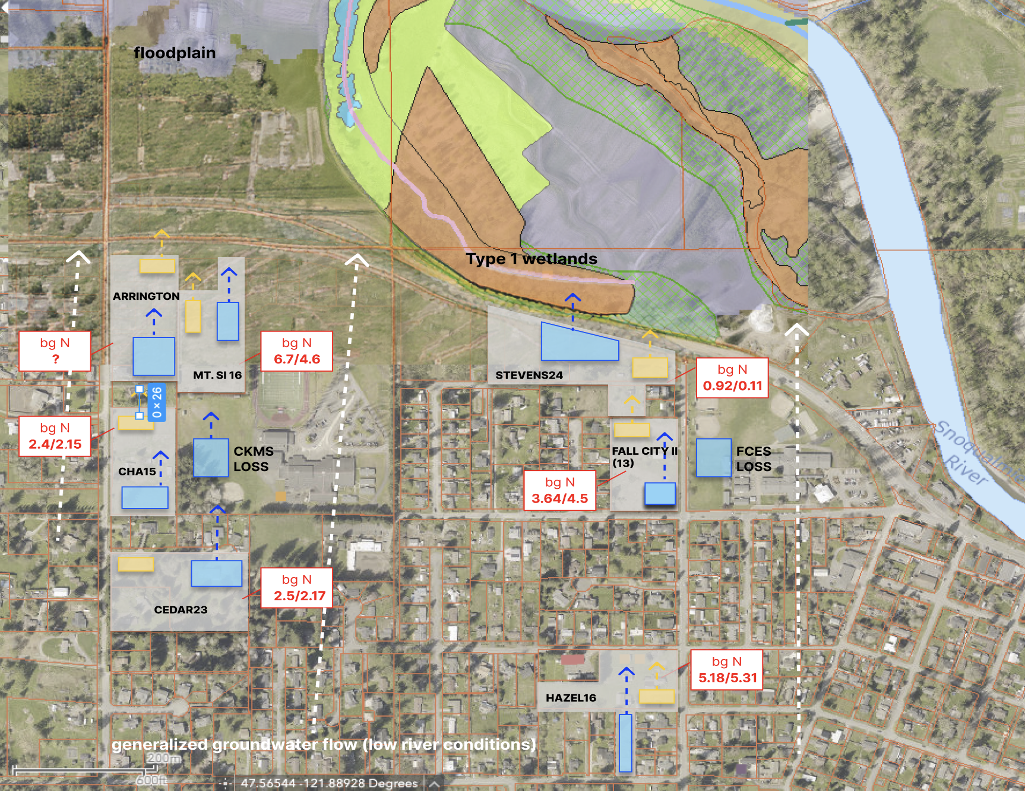
Natural background for this type of aquifer is approximately less than 1 mg/L. The difference between natural and current levels is not normal variation. It is contamination already present in the groundwater: the aquifer is showing nitrogen levels two to three times higher than natural.
The source is existing on-site septic systems throughout Fall City. King County zoning historically allowed up to 4 homes per acre in Fall City. The actual built density is closer to 2.1 homes per acre because individual septic systems require larger lot sizes to accommodate drainfields and setback requirements.
Looking at the levels on each plat it’s clear there is a connection between the location samples and nearby septics. For example, the lowest levels detected are close to background (Stevens24). This location is lightly developed and mostly open. On the opposite end of the spectrum the Mt. Si location measured up to 6.7, which could be because it is located adjacent to Arrington Court (has a history of failed treatment) and directly downstream from the Chief Kanim LOSS. Hazel is also quite high, it is located in a more densely developed part of town.
This suggests the existing septic load may be exceeding the capacity of the underlying soils to process nitrogen. The problem is diffuse: no single septic system is responsible, but the cumulative effect of hundreds of systems across the community has degraded the aquifer beyond its natural condition. This table is derived from King County’s Chapter 6: Critical Aquifer Recharge Areas (pg. 6-18) and shows results from a method to determine the minimum lot size necessary to require nitrate levels to reach no more than 5 mg/L (half the EPA drinking water limit). A WA DOH 2002 technical report suggested it could be necessary to either increase minimum lot sizes to 0.5-1.0 acres or require additional treatment for high-risk sites. What we see is Fall City already has a lot more septic systems per acre than what our government guidance says is safe.
The geology makes this worse. The gravel soils underlying most of Fall City provide essentially no denitrification. Nitrogen from septic systems moves directly into groundwater with minimal soil treatment. Over decades, that nitrogen has accumulated. The result is a shallow aquifer that already carries more than twice its natural nitrogen load before any LOSS systems are added.
Put plainly: the background data does not show a healthy aquifer with room to absorb more nitrogen. It shows a compromised resource that is already being degraded beyond its natural condition by the existing development pattern. Adding seven LOSS systems, each with a design nitrogen concentration of 10 mg/L in the effluent and zero soil attenuation before reaching groundwater, into that already-compromised system, is not a marginal incremental impact. It is further loading onto a resource that is already in trouble.
Regulatory Thresholds for Nitrate and Legal Consequences
Washington's groundwater quality standards establish a hierarchy of regulatory triggers for nitrate contamination. Understanding the numeric scale and the definitional gaps between thresholds is essential to evaluating compliance:
“Natural background” nitrate in unimpacted groundwater ranges from near-zero to approximately 1 mg/L, representing pristine conditions with minimal human influence. Fall City background is averages around 4.07 mg/L based on upgradient monitoring data. This concentration already reflects anthropogenic nitrogen loading from existing land uses and establishes the baseline against which new discharges are measured.
“Moderate impact” occurs when nitrate increases “more than 2 mg/L above background” (DOH July 2024).
“Maximum Contaminant Level” (MCL) is for Nitrate is 10 mg/L. This is the federal and state drinking water standard. Concentrations above 10 mg/L render water unsafe for human consumption, particularly for infants.
“Significant adverse impact” is defined under SEPA as "a reasonable likelihood of more than a moderate adverse impact on environmental quality." WAC 197-11-794. No numeric threshold is published for this standard for Nitrate. Washington regulations do not specify whether "more than moderate" means 2.1 mg/L, 3 mg/L, or some other value. The determination is contextual: the Stevens 24 Hearing Examiner found that cumulative loading exceeding the moderate threshold in a CARA over a de facto sole source aquifer constitutes “significant impact”, but did not establish a bright-line numeric value. This definitional gap leaves the threshold to agency interpretation on a case-by-case basis.
“Early warning value” triggers corrective actions before beneficial uses are degraded. WAC 173-200-070. The early warning value is calculated as the midpoint between background and the enforcement limit, approximately 5 mg/L under current Fall City conditions. Mt. Si and Hazel plats are currently above the early warning value threshold.
“High quality groundwater” is any groundwater with nitrate concentrations below the 10 mg/L MCL. WAC 173-200-030(2)(c). This is the antidegradation threshold: all groundwater cleaner than the drinking water standard receives mandatory protection against degradation unless overriding public interest and AKART are demonstrated.
Each LOSS is projected to add at least 2 mg/L at its point of compliance, meaning every individual system triggers the moderate impact threshold. Cumulative loading from seven systems operating simultaneously pushes concentrations past the early warning value and approaches the MCL itself, compressing the remaining assimilative capacity of an aquifer already carrying elevated background loads. Whether this cumulative loading constitutes "significant adverse impact" under King County Code 21A.24 depends on agency determination applying the "more than moderate" standard without numeric guidance.
What is the legal status of the Aquifer right now?
This existing contamination matters legally.
Regulatory thresholds and their legal consequences: Washington's groundwater quality standards establish a hierarchy of regulatory triggers for nitrate contamination. But first, let’s define the terminology used to describe contamination of groundwater.
“Natural background” nitrate levels in unimpacted groundwater are up to 1 mg/L.
Moderate impact DOH defines as an increase greater than 2 mg/L above background (DOH 337-069, July 2024), meaning any groundwater concentration exceeding 6.07 mg/L at Fall City constitutes moderate impact.
Under SEPA, a significant impact is defined as "a reasonable likelihood of more than a moderate adverse impact on environmental quality" (WAC 197-11-794), which translates to increases exceeding the 2 mg/L moderate impact threshold.
The MCL (Maximum Contaminant Level) for nitrate is 10 mg/L (WAC 173-200-040, Table 1), the federal drinking water standard above which water is unsafe for human consumption.
The state's early warning value - designed to trigger corrective action before beneficial uses are degraded - is calculated as the midpoint between natural background and the enforcement limit: approximately 5 mg/L. Each LOSS is projected to add at least 2 mg/L at its point of compliance, meaning every system triggers the moderate impact threshold. Cumulative loading from seven systems pushes concentrations past the early warning value and approaches the MCL itself.
High Quality drinking water: antidegrectaion, under the MCL
The aquifer qualifies as high-quality water under antidegradation law because it measures below the 10 mg/L drinking water standard. But it is already degraded from natural conditions. Adding seven LOSS systems that discharge more nitrogen into an aquifer with diminished assimilative capacity is exactly the scenario antidegradation law was designed to prevent.
We have established that Nitrate around Fall City has a natural background up to 1mg, and testing shows levels up to 6.7
The antidegradation framework does not treat a degraded aquifer as one with more room or that “is already polluted”. It treats it as a resource requiring greater protection. An aquifer that is already compromised, that is already above natural background, in a designated CARA, is exactly the condition that antidegradation law and CARA protections were written to arrest. Approving systems that add further load to a resource that is already failing to meet its natural water quality condition requires a higher level of scrutiny and justification, not a lower one.
How much Nitrate will the LOSS add to the Aquifer?
Before we jump in, we need to call out that the exercise of calculating the amount of Nitrate entering the aquifer collectively from these projects has not been formally completed. As a community, we could fund a formal analysis (quoted at around $70,000) but from our position this type of impact work should be required from the applicant by either King County or DOH.
That said, we will attempt to use some “back of the napkin” math to help articulate the extent and scale of impacts. The following is an estimate. It is not a substitute for a proper aquifer-scale model, and we will explain at the end why that distinction matters.
The assumptions and why we chose them
For the total amount of wastewater: the seven LOSS systems together serve 125 homes. The homes are marketed with four and five bedrooms, but we use three bedrooms here because that is the design basis DOH applies. Three bedrooms corresponds to a standard daily sewage flow of 360 gallons per home. That gives a total daily flow of 45,000 gallons per day, or approximately 170,000 liters.
For nitrogen concentration in the effluent, we use two scenarios. The first is a N=10 mg/L, the permitted treatment target: the level the systems are designed and required to achieve. The second is N=30 mg/L, which is a moderate estimate of what the systems may produce during periods of degraded performance. Operational data from the existing Arrington Court LOSS in Fall City, and from comparable systems elsewhere, shows that treatment performance drops during high-use periods such as holidays, cold weather events, and system upsets. Thirty milligrams per liter is not a worst-case figure. It is a reasonable estimate of what periodic underperformance looks like and is supported by data we found in public records.
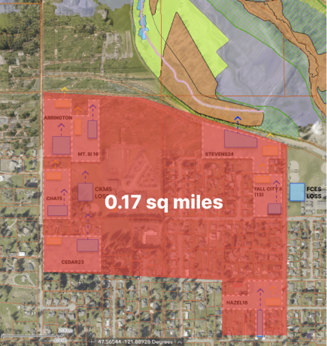
For the aquifer and dilution factors, we use a depth of 20 feet, which is the figure DOH's own nitrate balance guidance specifies. The seven LOSS sites together cover approximately 0.17 square miles. We use a porosity of 25 percent, meaning one quarter of the aquifer volume is actually water-filled pore space. This is a standard conservative default for alluvial sand and gravel. The site soil logs suggest the actual porosity is higher, which would increase the water volume and slightly soften the numbers below.
How much Nitrate will LOSS add?
The following is an estimation.
At N=10 mg/L, the seven systems together discharge approximately 1.7 kilograms of nitrogen per day, or roughly 620 kilograms per year into the shallow aquifer.
At N=30 mg/L, that rises to 5.1 kilograms per day, bringing the annual total under mixed performance to approximately 900 kilograms per year into the shallow aquifer.
Dilution and Accumulation
The next question is: how much does this nitrogen get diluted by the receiving water? To answer that, we need to know how big the aquifer is.
The calculated aquifer volume beneath the seven LOSS sites is approximately 780 million liters. If the annual nitrogen loading (1,370 to 4,110 pounds per year) were distributed evenly across this volume, the theoretical concentration increase would be 0.8 to 2.4 mg/L per year. Against a background already measured at 4 to 6 mg/L, that is not a small number.
But the dilution calculation assumes the aquifer works like a tank: a fixed volume into which you pour nitrogen each year and measure the result. The Kindred Hydro study proves the aquifer does not work that way. Groundwater flows at variable rates depending on the season. Nitrogen accumulates locally near each drainfield rather than spreading evenly. Water that enters the aquifer in summer may not discharge to the river until months later. And critically, nitrate is stable in oxygenated groundwater - it does not break down. Each year of operation adds nitrogen on top of what the previous year left behind.
The 4 to 6 mg/L background we measure today is itself the result of decades of this accumulation from existing septic systems across Fall City. The seven LOSS systems will accelerate that trend. The question is not whether the nitrogen will eventually reach the Snoqualmie River - the hydraulic connection proves it already discharges into the river. The question is how much additional degradation of the aquifer and the river Washington law allows.
The LOSS systems are not the only new nitrogen source the Taylor projects introduce. Each development also creates new impervious surfaces: roads, driveways, rooftops, and parking areas. Stormwater running off those surfaces carries nitrogen from atmospheric deposition, vehicle exhaust, and organic matter. That stormwater is managed through infiltration facilities that discharge to the same shallow aquifer as the LOSS systems. It is a separate regulatory process, permitted through a different agency, and it has never been combined with the LOSS nitrogen loading in a single cumulative analysis.
The LOSS analysis and the stormwater analysis exist in separate regulatory silos by design, each reviewed by a different agency against a different threshold. Neither agency has been asked to add the two numbers together. The result is that the total nitrogen loading from these seven projects into this aquifer has never been calculated.
What the aquifer concentration looks like after five or ten years of continuous operation by seven systems has never been modeled. That is the point. Our “back of the napkin” math here is meant to provide some scale to the conversation around impacts. It does not answer the question of cumulative impact over time, because that analysis has not been done.
The question is whether these systems can be legally permitted before we have data in hand.
Why Protection of the Shallow Aquifer Is Not Optional
The fact that Fall City's public supply wells are likely drawing from the deeper aquifer does not mean the shallow aquifer is unprotected or unimportant. It is a critical area under King County law, and it functions as a shared public resource in the same way that air does: everyone who lives over it, uses it, or draws from it is affected by what is put into it.
Several features make the shallow aquifer a resource that must be protected on its own terms. Private wells throughout Fall City draw from it directly. The confining layer separating the shallow and deep aquifers is not continuous: independent hydrogeologic review, including work by Mott MacDonald commissioned by the Fall City Water District, has found that the till layer separating the two systems is thin or absent in some areas, particularly near the river. Where that separation breaks down, contamination in the shallow aquifer can reach the deeper system. FCWD Well 5, the closest public supply well to the Taylor development sites, is one of the wells where the separation is described as less clear.
Beyond drinking water, the shallow aquifer drains directly to the Snoqualmie River. Water that enters the shallow aquifer eventually discharges to the river, carrying whatever dissolved contaminants it has accumulated. The Snoqualmie is a federally listed impaired water body, with nitrate among its documented impairments. The shallow aquifer is part of the same hydrologic system as the river.
Thinking about the shallow aquifer purely in terms of whether it threatens the public supply wells is too narrow. The right frame is a shared resource: once nitrogen enters it, everyone and everything connected to it is affected, including private well owners, the river, and the salmon that depend on the river. You cannot treat it as a disposal medium for one purpose and a protected resource for another. That is precisely what the Critical Aquifer Recharge Area designation was designed to prevent.